|
I like maps. On my recent Texas trip I had my iPad with
a good GPS and four different map
applications. You can see two
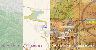
sets of screenshots from the various maps.
Long story short, I'm impressed with You Need A Map (and it's free!).
The four apps I tried were MotionX, a GPS tracker with terrain
maps from OpenCycleMap; OffMaps with their CloudMade/OpenStreetMap maps; You Need A Map with a variety
of raster and vector sources; and
ForeFlight, an aviation
specific map with VFR sectional charts. All of these apps support cached
offline map access, I store some 10 gigs of map data on the iPad. The
two locations I compared are near
the Guadalupe Pass in Texas and near
the Cajon Pass in LA, California.
The main thing I learned is how different maps can be. MotionX's terrain layer is designed for hiking with very detailed countours. But the shading isn't very good and it's easy to lose the big picture zoomed out as much as I do in a plane. OffMaps spare road maps have served me well driving around Europe but don't convey much terrain. Oddly they do indicate airport positions very well. ForeFlight is showing AeroNav's excellent VFR charts; great for pilots, not so much for anyone else. The real generalist is You Need A Map, whose combination of a terrain raster map with vector layers gives some really impressive maps. I'm particularly impressed with their dynamic terrain shading. Configurability is another interesting difference. You Need A Map is amazing: you have a choice of some 20 map layers to composite with different presets for emphasizing roads, natural features, points of interest, etc. It's the only iPad app I've seen to extensively use vector map data rendered in real time. MotionX, OffMaps, and ForeFlight all offer your choice of a handful of different raster layers but basically you take what they offer. Which can be perfect if, say, you're flying an airplane and using ForeFlight. One final difference is extra features. OffMaps and You Need A Map basically display maps and nothing else. MotionX is really a very fine GPS track recorder; the maps are just gravy. And ForeFlight is a full flight planning system. My conclusion from this experiment is that for flying trips, in addition to ForeFlight I'll be using You Need A Map. OffMaps will stay with me on my iPhone, its maps are really good for road navigation. I don't have much use for the MotionX maps but that'd change entirely if I were a hiker. |
||

