Tue 2025-04-15
Mon 2025-04-14
Fri 2025-04-11
Thu 2025-04-10
Tue 2025-04-08
Mon 2025-04-07
Fri 2025-04-04
Thu 2025-04-03
Search
Archives
2024
12 11 10 09 08 07 06 05 04 03 02 01
2023
2022
2021
2020
2019
2018
2017
2016
2015
2014
2013
2012
2011
2010
2009
2008
2007
2006
2005
2004
2003 One good site
MDN
Nelson Minar
Blog licensed under a Creative Commons License
|
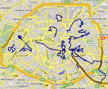
One of my favourite things to do in Paris is walk around, explore
neighbourhoods, and take
photos.
Thanks to
GMaps Pedometer
it was easy to retrace my steps after each walk and save the route as
a
KML file.
Then in
Google Earth
you can load all the walks, look at them, save them as a
merged KML file.
The result? A
Google
Map of a bunch of walks I've taken in Paris.
|
|
