|
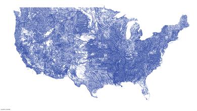
It’s been a good week for my river project. A lot of exposure on the Internet, 100,000+ viewers from Gear Junkie to a NASA Twitter account to that fine example of British tabloids, the Daily Mail (Online). I owe the new attention to Jason Kottke. He ran a blog post on my map and the traffic exploded, not just directly from his site but into the minds of other people. I’d actually gotten a lot of attention on Reddit MapPorn last month, but it didn’t go further than that. Kottke has a lot more reach, from BoingBoing to Reddit again to Popular Science to Wired Design to some traditional print publications that haven’t come out yet (if they ever do). I’m guessing Jason found my map from Mike Bostock’s talk at Eyeo, that’s a real kind of legitimacy you can’t buy. It’s a funny sort of brief fame for a little work print I did as a 45 minute aside on a much bigger project. I think people like that one picture because it’s easy to understand and looks cool, particularly the natural complexity of the earth. I feel bad I didn’t spend more time explaining this better. It’s not really a map of rivers at all, it’s flowlines, which may just as easily be seasonal streams or arroyos or drainage canals. A bunch of folks have asked about a poster version. I’d like one too and it’s not too expensive, so I may give it a go. First I need to fix those nasty rectangular artifacts; apparently an artifact of digitization on USGS quads. |
||

